
. Introduction
The Holocene alluvia within the Wisłok River valley were described for the first time more than 100 years ago by Friedberg (1903). Between Rzeszów and Trzebownisko L. Starkel (1960) distinguished several alluvial fills from the Late Glacial and the Holocene dated by the palynological method by K. Mamakowa. The current recognition of the stratigraphy of the Vistulian (Weichselian) and the Holocene alluvia of the lower Wisłok River valley is based on more than 30 radiocarbon and palynological age determinations of the sequences located mostly between Łukawiec and Łąka villages and the town of Łańcut (Gębica et al., 2002, 2009; Gębica, 2004, 2011; Kołaczek, 2007, 2010) (Fig. 1B).
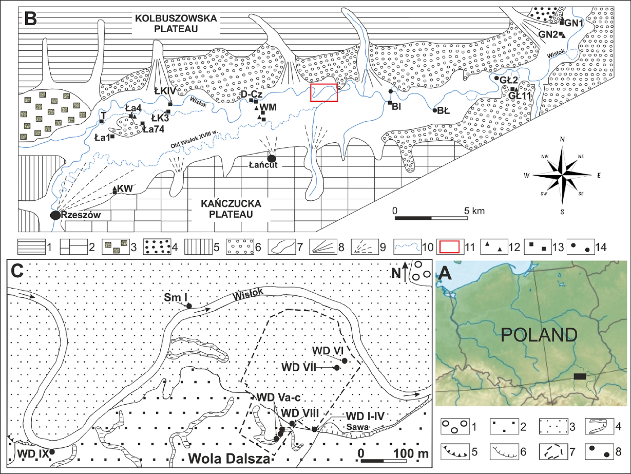
Fig. 1
Maps with location and geomorphology of study area.
General location of the study area.
The Wisłok River valley and the Late Glacial and Holocene alluvia with sites sampled for the radiocarbon datings (elaborated by P. Gębica). Explanation of symbols: 1 – Kolbuszowska Plateau covered with sediments of the Elsterian Glaciation, 2 – Kańczucka Plateau covered with Saalian 2 (Wartanian) and Vistulian loess, 3 – fluvioglacial plain, Elsterian 2 Glaciation, 4 – river terrace 13–18 m high, Saalian 2 (Wartanian), 5 – loess terrace 15–20 m high, Vistulian, 6 – Vistulian (sandy) terrace 8–12 m high, with dunes, 7 – erosional-denudation valley, 8 – Pleistocene alluvial fan, 9 – Holocene alluvial fan, 10 – Holocene floodplain 7–8 m high and systems of palaeochannels, 11– study area, 12 – sites of the Late Glacial sediments, 13 – sites of the Early Holocene sediments, 14 – sites of the Last Millenium sediments. List of the sites dated by radiocarbon and palynological methods: SŁ – Słocina, KW – Krasne-Wólka, Ła1 – Łąka 1, Ła4 – Łąka 4, T – Terliczka, Ła 74 – Łąka archaeological site No. 74, ŁkIV – Łukawiec IV, Łk3 – Łukawiec 3, CzP – Czarna Podbór, D-Cz – Dąbrówki-Czarna, WM – Wola Mała, BI – Białobrzegi, BŁ – Budy Łańcuckie, GŁ2 – Gniewczyna Łańcucka 2, GŁ11 – Gniewczyna Łańcucka 11, GN1 – Grodzisko Nowe 1, GN2 – Grodzisko Nowe (Dolne) 2.
Wola Dalsza gravel pit and the location of sequences described in the text (elaborated by S. Superson). Explanation of symbols: 1 – Vistulian sandy terrace 8–12 m high, 2 – Holocene terrace 7–8 m high, 3 – floodplain 5–6 m high, 4 – palaeochannels, 5 – erosional edges higher than 1 m, 6 – erosional edges up to 1 m high, 7 – extent of gravelpit, 8 – study sites, Sm – Smolarzyny site.
The study of recently outcropped depositional sequences located in the erosional undercuts of the Wisłok riverbed and in the gravel pits recently opened due to the construction of the A-4 highway, made it possible to recognise the structure and the stratigraphy of the Wisłok River valley alluvia between the towns of Łańcut and Przeworsk (Gębica et al., 2014; Superson, 2014; Superson et al., 2016). Therefore, the objective of the related study is the reconstruction of chronostratigraphy of the Holocene alluvia in the Wisłok River valley with particular emphasis on the position, genesis and age of the Early Holocene organic sediments dated by the radiocarbon method and palynological analysis. An attempt was also made to explain the preservation of the erosional bench formed of the Early Holocene organic sediments within the 5–6 m high floodplain in the context of historical changes of the Wisłok River channel. Moreover, one of the considered palaeogeographic problems is the functioning of rivers in the Early Holocene (10 200–8600 BP; 11 500–9500 cal BP), which was characterised by the stabilisation expressed by lower frequency of flood occurrence (Starkel, 1995, 2001) in this period and at the same time the intensification of organic accumulation.
. Study area
The Wisłok River is the longest tributary of the San River. In the 40 km long section it flows along the latitudinal erosional depression named the Fore-Carpathian Trough (Rynna Podkarpacka) (Starkel, 1972), through which during the San 2 (Elsterian) glaciation glacial waters flowed eastward toward the Dniester River basin. The bottom of the valley, eroded in Miocene clays is covered with Vistulian (Weichselian) and Holocene alluvia. The terraced floor of the valley is framed from the south and the north by the edges of the plateaus (Fig. 1B). Between the towns of Rzeszów and Łańcut the 4–6 km wide Holocene valley floor is covered in the southern part by a system of paleochannels of the Old Wisłok (Stary Wisłok) River (Fig. 1B), while in its northern part the present Wisłok River channel is located after its avulsion in the middle of the 18th century (Strzelecka, 1958). Both parts of the valley, filled up with the Late Vistulian and Holocene alluvia, are separated by an erosional remnant of the Vistulian terrace (Gębica, 2004). To the east of Łańcut the area occupied by this terrace increases, the width of the valley bottom ranges from 3 to 4 km, while the floodplain width ranges from 0.8 to 1.5 km.
The study area is situated in the northern part of the Fore-Carpathian Trough, in the village of Wola Dalsza, about 5 km north-east of Łańcut (Fig. 1B). On a cross-section of the valley, through the area of this village, a Vistulian terrace covered by dunes with a height of 8–12 m (above the riverbed), a 7–8 m high terrace and a 5–6 m high floodplain occur. In the 1.3 km wide floodplain numerous paleomeanders occur. The apparent erosional edge of paleochannel visible on Fig. 1C, which separates the 7–8 m high terrace from the floodplain, marks the location of the Wisłok channel in the 70-ties of 19th century (Special map, 1878).
. Materials and methods
After an initial survey of the accessible outcrops, 8 sequences located using the GPS (Global Positioning System) system were selected for further detailed examination and sampling. At the selected sites the sequences up to 7–8 m long in the outcrops were described and supplemented with archival bore-hole data up to the length of 11–13 m. Moreover, the sequences at the neighbouring sites in the village of Smolarzyny were examined in detail. 13 samples of peat, organic silt, charcoal as well as fragments of wood and tree trunks were collected. Five of these samples were dated by the radiocarbon method in the Department of Radioisotopes, Silesian University of Technology in Gliwice (Lab. code begins with GdS). One sample of fossil tree trunk, taken from the outcrop in the Wisłok floodplain at a distance of 1 km west of the gravel pit (Fig. 1C) was dated by the radiocarbon method in the Laboratory of Absolute Dating in Skała near Cracow (Lab. code begins with MKL) (Table 1). The sample for the palynological analysis was taken from the Smolarzyny sequence.
Table 1
Radiocarbon datings of samples from the sequence in the Wola Dalsza gravel-pit.
Consequently, the following 8 samples of organic deposits were selected for conventional radiocarbon dating (LSC) of: one sample of charcoal, 3 peat samples, 3 wood samples and one sample of fired clay with coal dust. However, the content of organic material in this last sample was too small for dating using the conventional technique. Furthermore, the charcoal sample of a weight of 1 g was too small for reliable conventional dating. Therefore finally, the reliable results of 6 age determinations were taken into account and are presented in Table 1.
All samples underwent the standard procedure of initial preparation acid-alkali-acid, and then they were decomposed and converted into benzene (Pazdur et al., 2003). The radiocarbon dating was performed applying a liquid scintillation technique (LSC method) and using alpha/beta spectrometers: Quantulus 1220 and ICELS (Pawlyta et al., 1998; Tudyka and Pazdur, 2010; Tudyka et al., 2015). Calibration of radiocarbon dates was carried out using the computer calibration program OxCal 4.2 (Bronk Ramsey et al., 2010) based on the calibration curve IntCal13 (Reimer et al., 2013).
The palynological analysis was used for the verification of the age of the sediments determined by radiocarbon dating. Therefore, this analysis was performed for 6 samples taken from 6 depositional sequences of the 7–8 m high terrace and the floodplain, which were also dated by the radiocarbon method. Furthermore, the tree species composition of charcoal fragments in the overbank sediments was examined. The species identification of charcoal fragments was based on anatomic wood structure. The charcoal fragments were prepared for microscopic observation by cutting them along three anatomic cross-sections characteristic for botanic material: transversal, longitudinal-radial and tangential longitudinal. In order to record all anatomic details characteristic for particular tree species examination of fragments larger than 4 mm3 is recommended, nevertheless, smaller but accurately preserved particles are usually also identifiable (Chabal et al., 1999). The charcoal fragments were examined in a metalographic microscope Zeiss AXIO Lab. A1 using a magnification from 100 up to 500 times, and then comparing the pictures with anatomic codes (Schweingruber, 1982, 1990) and specimens from the comparison collection in the Palaeobotanic Department of the W. Szafer Institute of Botany, Polish Academy of Sciences in Krakow.
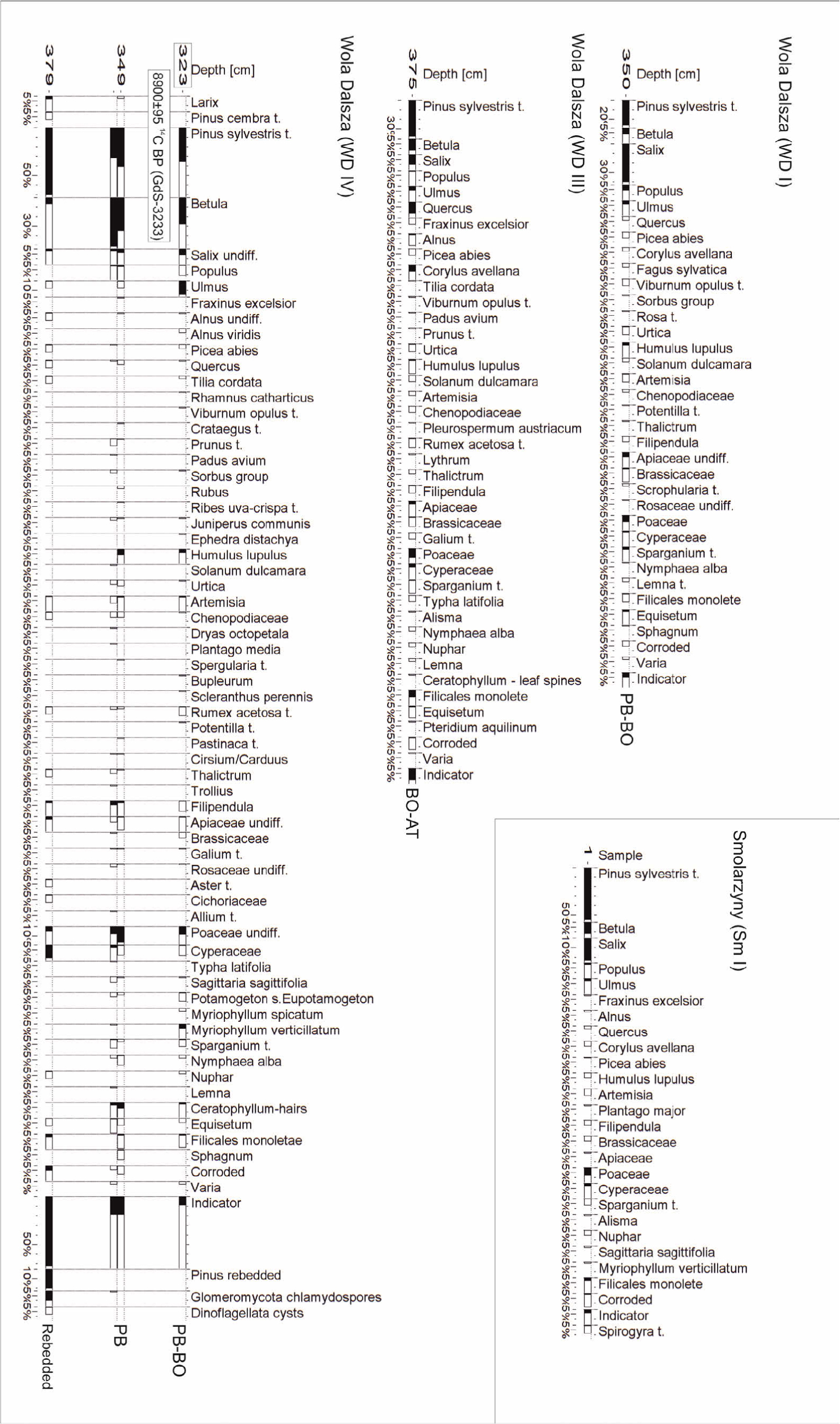
Moreover, in the south-east face of the gravel pit in the profie WD IV the organic (peat) sequence of undisturbed fabric (vertical column) 57 cm long was sampled in order to perform palynological analysis. From the sequence WD IV four samples were analysed (Fig. 1C), while in the two neighbouring sequences (WD III and WD I) additional two samples were analysed. The results of these analyses were used for the construction of the simplified palynological diagrams (Fig. 4), which illustrate the composition and the percentage of plant species. The samples were prepared using standard laboratory procedures (Berglund and Ralska-Jasiewiczowa, 1986).
Fig. 2
Geological cross-section of the floodplain (5–6 m high) and terrace 7–8 m high with the location of the sequences and samples dated by the radiocarbon and palynological methods (elaborated by S. Superson). Explanation of symbols: 1 – gravel, 2 – sand with single pebbles, 3 – sand, 4 – silt, 5 – flood rhytmithe, 6 – clay, 7 – tree trunks, 8 – wood fragments, 9 – peat, 10 – charcoal fragments, 11 – fired clay bearing coal dust, 12 – anthropogenic embankment; PAL-palynological dating, AT-Atlantic, SB-Subboreal, SA-Subatlantic
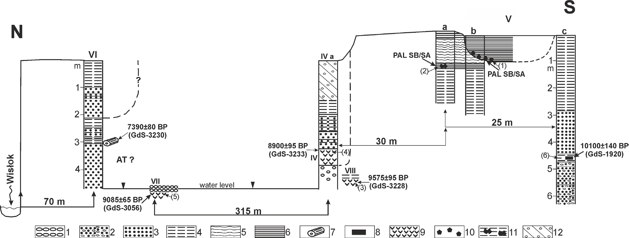
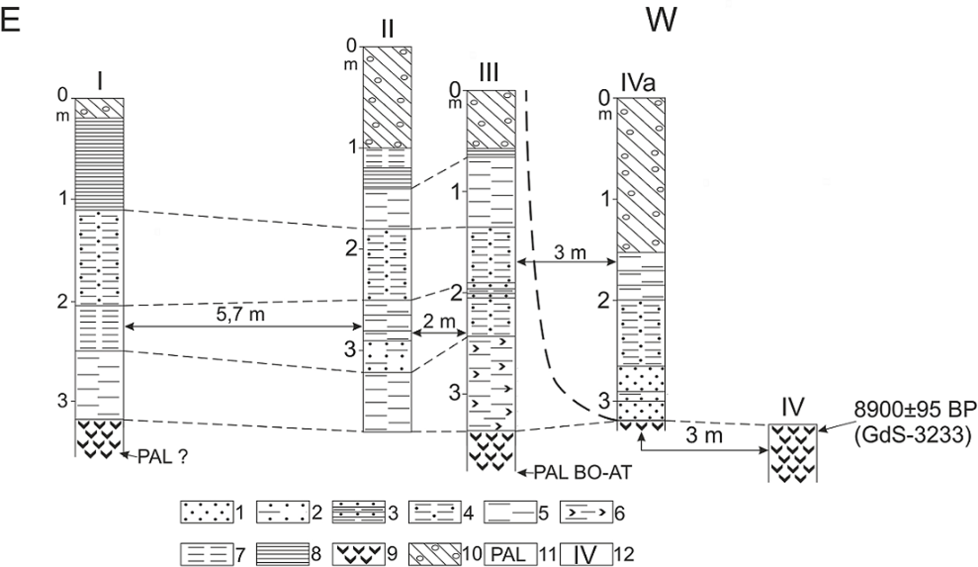
Fig. 3
The structure of floodplain 5–6 m high bearing peat, eroded in the sequence IV (elaborated by S. Superson and P. Gębica). Explanation of symbols: 1 – sand, 2 – silty sand, 3 – laminated sand, 4 – silt with sand, 5 – silt, 6 – organic silt, 7 – clayey silt, 8 – clay, 9 – peat, 10 – anthropogenic embankment, 11 – palynological analysis, 12 – number of the sequence; Bo-Boreal, AT-Atlantic.
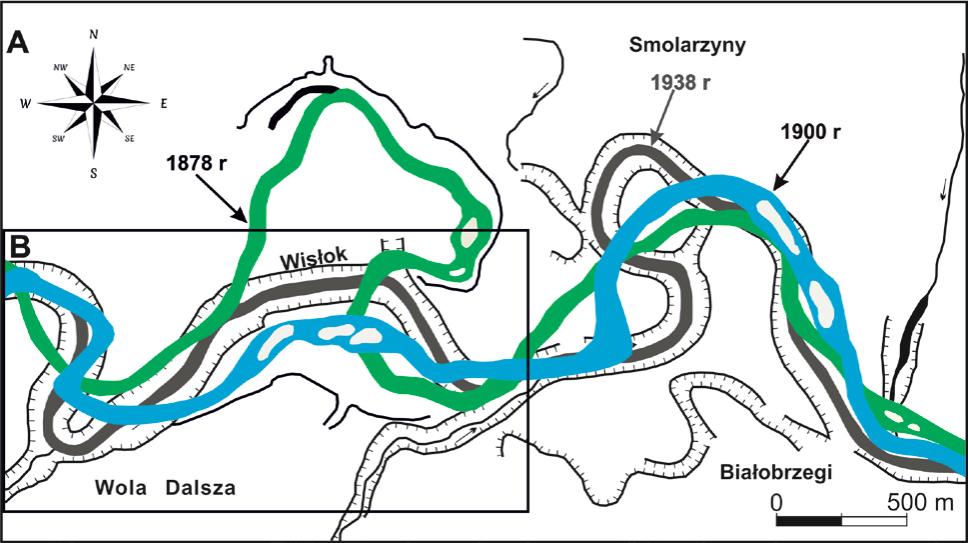
Furthermore, the cartographic materials that were produced in 1878, 1900, 1938 in the scale 1 : 100 000 (Topographic map, 1938) and 1 : 75 000 (Special map 1878, 1900), illustrate the changes in the Wisłok River channel development in 19th and 20th centuries.
. Results and interpretation
Characteristics of alluvial fills
The structure of the 7–8 m high terrace is tripartite. Its substratum is formed of Miocene clays (Laskowska-Wysoczańska, 1971; Gębica, 2004). At a depth of 11–13 m these clays are overlain by 5–7 m thick sand-gravel channel alluvia that bear overbank silt inserts and wood fragments (Fig. 2). The macroscopic description of their structural and textural features were described and 70 samples were collected, however, the granulation (grain size) analysis has not been made, yet. The younger fill is formed of sands, that are fine- and medium-grained and through cross-bedded. The higher part of the sequence (WD V and WD IX) is formed of clays and clayey silts of massive structure up to 3 m thick, underlined by flood rhythmite layer. In the sequence bottom sand-gravel through cross-bedded alluvia occur that are inserted with silts. The youngest unit is represented by clays filling the overflow channels. These clays bear charcoal fragments. The erosional bench within the floodplain is formed of peat sediments truncated by erosion, which are outcropped in several sites of the distal part of the floodplain. Peat sediments were accumulated in paleochannels. They are covered by sands and silts horizontally bedded (Fig. 3). In the sequence IVa the peat is overlain with fine and medium grained sands, whereas in other sequences (Fig. 3) the peat sediments are directly overlain by clayey silts. In the proximal part of the floodplain channel sands occur that are through cross-bedded (Fig. 2). They are overlain by sand-silt alluvia of the natural levee 3 m thick with ascending ripple marks. Within the boundary zone between the channel and the overbank alluvia tree trunks and wood fragments were found (Fig. 2).
Palynological analysis
The peat samples taken in the outcrops of the floodplain sediments (sequences WD IV, VII, VIII and Sm I) (Figs. 1C, 3), are characterised by very similar pollen spectra abounding with scots pine (Pinus sylvestris type), birch trees (Betula), willow (Salix), elm (Ulmus) and oak (Quercus), which indicates the peat deposition during the Preboreal or Boreal Phases (Klimek et al., 2006; Kołaczek, 2010, 2011). The silt sample with wood fragments and organic matter from a depth of 4.60–4.65 m (sequence Vc) does not contain pollen grains (Table 2). At the top of the 7–8 m high terrace clay sediments of the shallow channel fills with charcoal horizon were examined. In the sample of these sediments taken at a depth of 0.6–0.8 m no pollen grains were found, while the charcoal fragments represent oak (Quercus), hornbeam (Carpinus) and ash (Fraxinus) (Table 2).
Table 2
The results of palynological analysis (amount of pollen grain) of six samples of organic sediments from the Wola Dalsza site (analysed by K. Szczepanek).
At a depth of 1.5 m, under the flood rhythmite layer, coal dust occurs on the surface of and inside hard clay aggregates that resemble fossilized/carbonized wood (Fig. 2, Va sequence). On the basis of anthracological analysis the age of the samples bearing charcoal fragments can be ascribed to the Subboreal and/or the Subatlantic Phase.
Up to now four samples taken from WD-IV sequence of the peat have been analysed. The sample from a depth of 3.79 m is characterised by low pollen concentration, but by high content of redeposited pine pollen grains (see Pinus redeposited on Figs. 3, 4A) and spores of fungi of Glomeromycota division, which proves the intensive supply of terrestrial material (Kołaczek et al., 2013). The samples from a depth of 3.52 and 3.49 m represent the period of pine (Pinus) and birch (Betula) predomination in the surrounding forests, however, the lack of the above-mentioned fungi and corroded pollen grains suggests smooth deposition of organic material in an oxbow-lake. In the top sample from a depth of 3.23 m the increase in elm (Ulmus) tree content is recorded that coexisted in the forests with pine (Pinus) and birch (Betula). This enables attributing this sample to the Preboreal Phase (Klimek et al., 2006; Kołaczek, 2010, 2011). The sample from a depth of 3.50 m in the sequence WD I (Fig. 3) is characterised by a very high content of willow (Salix) pollen, which makes difficult the identification of the time of the peat deposition. The youngest is the sample from a depth of 3.75 m in the sequence WD III, which is characterised by a high content of oak (Quercus; ca. 10%) and hazel (Corylus avellana) that can indicate the Boreal or the Atlantic Phase (Kołaczek, 2010, 2011).
Anthracological analysis
The sediment sample bearing charcoal fragments, taken from the Vb sequence at the Wola Dalsza site at a depth of 60–80 cm, was used for the anthracological analysis (Fig. 2). The charcoal fragments were well preserved. Three tree taxa were recorded: Auropean hornbeam Carpinus betulus (3 fragments), European ash Fraxinus excelsior (13 fragments) and oak Quercus sp. (13 fragments). One hornbeam specimen was a fragment of a small branch. Each charcoal fragment is usually identified, regardless of its size. In the case of the sample from Wola Dalsza, the fragments larger than 1 mm3 were examined. The analysis were stopped after the examination of 30 fragments, because all taxa were recorded in the first four examined samples and no new taxon was found during the further observations. The charcoal fragments occurring in particular part of sediments often suffer subsequent fragmentation, which can bring about over-representation of one taxon in such agglomeration.
Consequently, the qualitative analysis of such specimen of charcoal seems to be more adequate than quantitative one.
In regard to the result of the anthracological analysis, particularly, on the basis of hornbeam occurrence that is characteristic for the Neoholocene forests, the sample age was ascribed to the Subboreal or/and Subatlantic Phases.
Results of radiocarbon dating
Six samples from the eight ones have sufficient weight for radiocarbon dating. The content of organic material in the samples bearing coal dust and charcoal was too small for the dating using the conventional technique (Table 1). The oldest alluvia within the 7–8 m high terrace are represented by channel gravels and sands with insert of clayey silts and wood fragments dated in the sequence Vc at a depth of 4.60 m at 11 960–11 395 cal BP (probability level: 68.2%; sample GdS-1920: 10 100 ± 140 BP) (Table 1, Fig. 2). The peat deposited within an oxbow-lake, sampled in the boundary zone between the 7–8 m high terrace and the floodplain at a depth of 4.50 m in the sequence VIII was dated at 11 095–10 755 cal BP (probability level: 68.2%; GdS-3228: 9575 ± 95 BP), while the peat sample from the sequence IV within the floodplain, taken at a depth of 3.20–3.25 m in the northern part of the outcrop was dated at 10 195–9885 cal BP (probability level: 68.2%; GdS-3233: 8900 ± 95 BP) (Fig. 3). The tree trunk buried in the channel alluvia (sequence WD IX) at a depth of 5.80–5.90 m and dated at 10 520–10 300 cal (probability level: 68.2%; MKL-2786: BP 9290 ± 50 BP) is also ascribed to the Preboreal Phase.
The amount of charcoal in the clay layer at the top of the 7–8 m high terrace, sampled at a depth of 0.6–0.8 m was too small for the conventional radiocarbon dating (Fig. 2). In the same sequence, at a depth of 1.5 m, under the horizon of the silty-sandy flood rhythmite, coal dust occurs on the surface and inside hard clay aggregates, that resemble fossilized wood fragments.
In the northern part of the gravel pit within the floodplain, ca. 70 m from the present riverbed, the wood fragment sampled in the boundary zone between channel and overbank alluvia, at a depth of 3.00 m, was dated at 8335–8155 cal BP (probability level 68.2%; GdS-3230: 7390 ± 80 BP) (Fig. 2).
Analysis of archival maps
Analysis of cartographic materials proves that in the 70-ties of the 19th century the meandering Wisłok River channel of a width of 80–120 m, undercut the edge of the Vistulian terrace in a distance of ca. 1 km north of the current riverbed. In an area of the gravel pit the river channel that was moving toward the south (Fig. 5), eroded the Early Holocene organic sediments and simultaneously aggraded the floodplain, forming the youngest series of overbank sediments. At the turn of the 19th and 20th centuries a meander in the northern part of the valley (Fig. 5) was cut and a new, straightened river channel, 100–150 m wide, of meandering and braided character, was formed.
Fig. 5
Changes of the Wisłok River channel during the 19th and 20th centuries (elaborated by S. Superson). A. Changes of the Wisłok Rivet channel between Wola Dalsza and Białobrzegi, B. The area presented on Fig. 1C in detail.
. Discussion
In the valley section between the villages of Trzebownisko and Łukawiec the floodplain occupies the area of a width of 200–300 m, whereas to the east of Łańcut its width increases up to 1.5 km. The organic sediments occurring in its bottom at a depth of 3–4 m represent the Interplenivistulian and are overlain by the Late Glacial and the Holocene alluvia (Gębica, 2004). To the east of the sites in the villages of Łąka and Łukawiec the Plenivistulian sediments are absent in the bottom of the 7 m high terrace, which suggests intensive downcutting of the Wisłok River in this part of the valley.
The preservation of the Early Holocene organic sediments forming the erosional bench of the floodplain (Figs. 1C, 2, 3) at a depth of 3.2–4.6 m indicates the predominance of lateral migration of river channel over its deepening. The occurrence of contemporary organic sediments in the southern and northern parts of the gravel pit as well as their similar stratigraphic position (Figs. 1C, 2) suggest the lack of fluvial activity in this zone, confirming the opinion of L. Starkel (1995), who postulated the stabilisation of river channels in that time. The environments suitable to the peat accumulation occurred at least from the beginning of the Boreal Phase (8900 ± 95 BP, 10 195–9885 cal BP GdS-3233) probably up to the Atlantic Phase, as suggested by the palynological analysis (Fig. 3). Similar series of organic sediments were dated in the paleochannel of the Wisłok River at the sites in the villages of Wola Mała and Dąbrówki (Gębica et al., 2009) and in the Drwinka depression in the Vistula River valley (Starkel et al., 1991). At the other hand, the occurrence of channel alluvia with tree trunks dated to the Preboreal and Boreal Phases at the sites in Białobrzegi (Gębica, 2011; Gębica et al., 2014; Superson unpubl.) and Wola Dalsza villages (dated at 10 100 ± 140 BP, 11 960–11 395 cal BP, GdS-1920: (Fig. 2, Table 1), suggests the intensive fluvial activity of the Wisłok River and the occurrence of the peaty plain to the south of above mentioned sites. The tree trunks buried in the channel alluvia that are recorded in the WD IX sequence (Figs. 1B, 1C) probably are not redeposited, because at the mentioned above Białobrzegi site, the trunks occur at the similar depth (5.8–6.2 m) and their radiocarbon ages indicate the Preboreal Phase (9900–9100 BP) (Gębica, 2011; Gębica et al., 2014). The unequivocal determination of the period of the erosional truncation of the organic deposits is difficult. This could have started in the Atlantic Phase, as suggests the dating 7390 ± 80 BP, (8335–8155 cal BP, GdS-3230). The dating of the deposition of blanket of overbank sediments is also problematic. In the vicinity of the current Wisłok riverbed the natural levee sediments, covered by silt-clay alluvia, occur. This allows to suppose, that they were deposited in the last several hundreds of years, similarly to the alluvia of the floodplain in Białobrzegi (Superson, unpubl.) and Budy Łaącuckie villages (Superson, 2014). The young age of the overbank sediments is also indicated by analysis of the cartographic materials from the 19th and 20th centuries, which document the Wisłok River channel avulsions in that time. The anthracological analysis of the charcoal sample from the top part of the terrace 7–8 m high, indicates the deposition of the silt-clay sediments during the Subboreal and Subatlantic Phases (Fig. 2). The charcoal particles which underwent long transport, would have become destroyed, therefore their agglomeration and accurate state of preservation in the sediment suggests their accumulation in situ.
. Conclusions
The palynological analysis and the radiocarbon dating made it possible to determine the Early Holocene age (Preboreal and Boreal Phases) of the organic oxbow-lake sediments situated in the northern part of the Wisłok River valley.
The attempts to perform the conventional radiocarbon dating of the horizons with charcoal fragments failed owing to the small amount of organic material sampled and subsequently obtained after the benzene preparation in the laboratory. The anthracological analysis of the charcoal sample reveals the occurrence of the tree taxa typical for the Neoholocene, which suggests that the deposition of clay sediments occurred during the Subboreal and/or Subatlantic Phases.
The preservation of the Early Holocene organic sediments within the floodplain indicates the predomination of lateral migration of the river channel and the consequent erosion of the wide plain aggraded with flood (overbank) alluvia during the last 200 years. In the 20th century the aggradation of the floodplain was synchronous with the deepening of the Wisłok River channel.
The radiocarbon ages obtained for the channel alluvia with tree trunks and peat horizons indicate the synchronicity of the organic deposition and the functioning of the active channel in the Early Holocene, which only partly confirm the hypothesis of L. Starkel (1995), that postulates the stabilisation of fluvial systems in that period.