
. Introduction
This paper presents chronometric research at three Iron Age extreme upland sites (EUS) in the Western Carpathians, North Slovakia (Figs. 1 and 2; Supplementary Online Material, SOM 1). The EUS occur in the regions of Liptov and Kysuce at 1000–1600 m a. s. l. (Pieta, 1981, 1983, 2000; Šedo, 1981–1982) and in the middle Váh river valley and Turiec region at around 600–900 m a. s. l. (Pieta, 2006, 2014). They represent the local culture of the Late/Final Bronze Age, Hallstatt, and La Tène periods and are parts of settlement systems organised along the mountain ridges (Fig. 2). Such a settlement system consists of unfortified settlement(s) on the basin or valley floor, hillfort(s) on lower promontories and finally EUS (Pieta, 1981: 58, 59, 61, 1983: 44; Benediková, 2006, 2017; Benediková and Pieta, 2020).
Fig 1.
The view from the Liptov basin towards the Nízke Tatry mountain range. 1 – Demänovská hora (known also as Demänovská Poludnica, cadastre of Demänovská Dolina and Liptovský Mikuláš-Ploštín), 2 – Končitý vrch (cadastre of Závažná Poruba), 3 – Iľanovská Poludnica (cadastres of Závažná Poruba and Liptovský Ján), 4 – Bodová, 5 – Rohačka, 6 – Pod Rohačkou. © Photo by Lucia Benediková, modified by Mária Hajnalová.
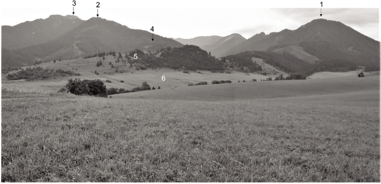
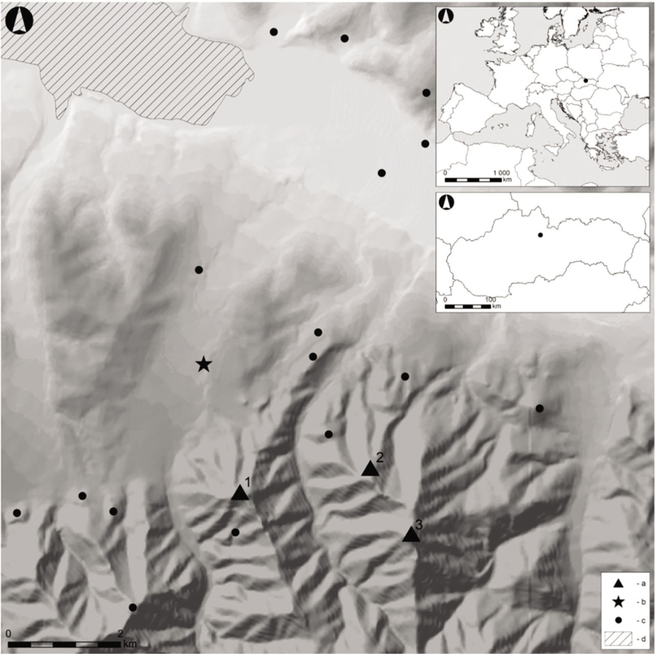
Fig 2.
Location of sites discussed in the text and other contemporary sites. 1 – Demänovská hora, 2 – Končitý vrch, 3 – Iľanovská Poludnica; a – sites discussed in the text, b – local pollen core of Demänovská slatina currently under study, c – archaeological sites dated to the period from Late Bronze Age to the Early La Tène period, d – the Liptovská Mara water reservoir. © Map by Jakub Tamaškovič.
The EUS are in the literature referred to as places of safety or refugia with possibly also other functions as seasonal shelters for animal herds (Pieta, 1981, 1983). We hypothesise that some of them may also have served as Brandopferstätte. These specific upland sacrificial sites for burnt offerings are known from Alpes-de-Haute-Provence to Styria and are dated from the Late Bronze Age to the Roman Period (Heiss, 2014: 343; Ballmer, 2017: 82). By now, they have not been considered for the Western Carpathians (Benediková et al., in preparation).
In the Liptov basin, up to 10 EUS are known (Benediková et al., in preparation). Three of them yielded rich finds of charred plant remains (Demänovská hora, Končitý vrch and Predný Choč; Pieta, 1983: 39–40). This is in strong contrast to coeval settlements on the valley floor, which did not produce similar finds (Benediková et al., in preparation). The occurrence of large quantities of charred cereal and pulse crops was interpreted as food stores charred during ‘catastrophic events’, but have not been addressed in detail by now. In the literature, the ‘catastrophic events’ were associated with the arrival of Eastern nomadic tribes towards the end of the Hallstatt Period or with the emergence of bearers of La Tène culture (Pieta, 1981: 62, 1983: 44; Pieta et al., 2021).
We focus on the temporal aspect of the charred pulse and cereals crops at three EUS: Demänovská hora, Končitý vrch and Iľanovská Poludnica. The first two, with typo-chronologically identical pottery (Fig. 3) and metal finds (e.g. bronze arrowheads of eastern type, bronze boat-shaped brooches, bronze S-shaped ear rings of eastern type, iron rolled headed pin; Fig. 4; Benediková, 2006, 2017: 357; Furman et al., 2019; Pieta et al., 2021), have yielded very rich assemblages of charred plant macro-remains dominated by pulse crops from very well cleaned stores (Benediková et al., in preparation).
Fig 3.
Pottery from excavations in 2015. 1–12 – Demänovská Dolina – Liptovský Mikuláš-Ploštín (Demänovská hora); 13–22 – Závažná Poruba (Končitý vrch). Drawn by Jana Gajdošíková. After Benediková et al., 2020, Figs. 20 and 21, modified.
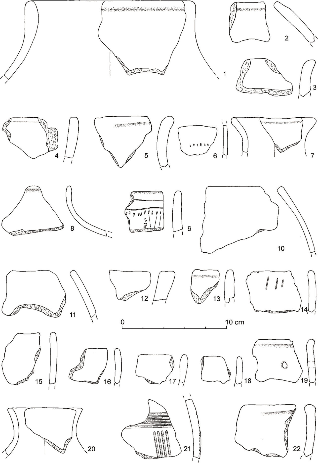
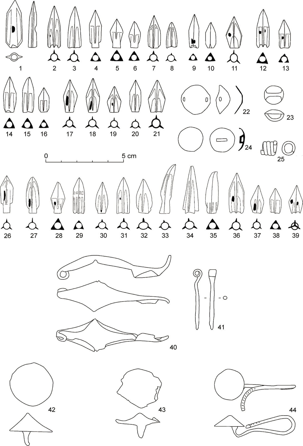
Fig 4.
Metal finds from surveys at Demänovská hora. 1–25, 40–44 – finds from 2018 survey; 26–39 – finds submitted to the Monuments Board Žilina office by treasure hunters. 41 – iron; others, bronze. Drawn by Martin Furman. After Furman et al., 2019, Figs. 2 and 3, modified.
With accelerator mass spectrometry (AMS) 14C dating of the charred crops, our aim is to test the narrative of short-event destructions in the Late/Final Hallstatt or Early La Tène periods. We are pursuing two main research questions:
. The Sites
The three studied EUS are situated in the mountain massif on the northern slopes of the Nízke Tatry mountain range. Going from lower to upper elevations, they occupy the summits of the second (Demänovská hora, Končitý vrch) and third lines of peaks (Iľanovská Poludnica) on the main ridges rising southwards from the Liptov basin. All are well protected hard-to-reach places clearly visible from the valley (Fig. 1). Based on their location, fortification, material culture and other archaeological evidence, they have been interpreted as refugia – the last retreat places of prehistoric communities in the times of danger (Pieta, 1981, 1983).
Based on the bronze and iron ornaments, weaponry, pottery vessels and coins discovered at these sites, it can be ascertained that they were in use in the Late and Final Bronze Age, Late and Final Hallstatt and Early La Tène period, and in the Middle Ages.
The studied EUS are understood as an integral part of the local Bronze and Iron Age settlement hierarchy (Pieta, 1981: 58, 59, 61, 1983: 44; Benediková, 2006, 2017; Benediková and Pieta, 2020). The Late and Final Bronze Age artefacts are known only from Iľanovská Poludnica and might connect this EUS with a hillfort on Bodová (Pieta, 2002: 156–158). The Hallstatt and Early La Tène finds were recovered at all three EUS (Benediková, 2006; Pieta, 1981, 1983; Pieta et al., 2021). During that time, Demänovská hora (1304 m a. s. l.) formed a settlement system with a hillfort on Rohačka (857 m a. s. l.) and an open settlement Pod Rohačkou (650–700 m a. s. l.) (Pieta, 1980, 1981, 1983; Šimková, 2004; Benediková, 2008; Benediková et al., 2019: Fig. 1). Since their lowland settlements and hillforts are unknown by now, Končitý vrch (1310 m a. s. l.) and Iľanovská Poludnica (1549 m a. s. l.) seem to stand so far in isolation in what we see as the Iron Age landscape. The mediaeval human activity is known only from Končitý vrch, where a coin forgery workshop has been found (Furman, 2020).
. Material and Methods
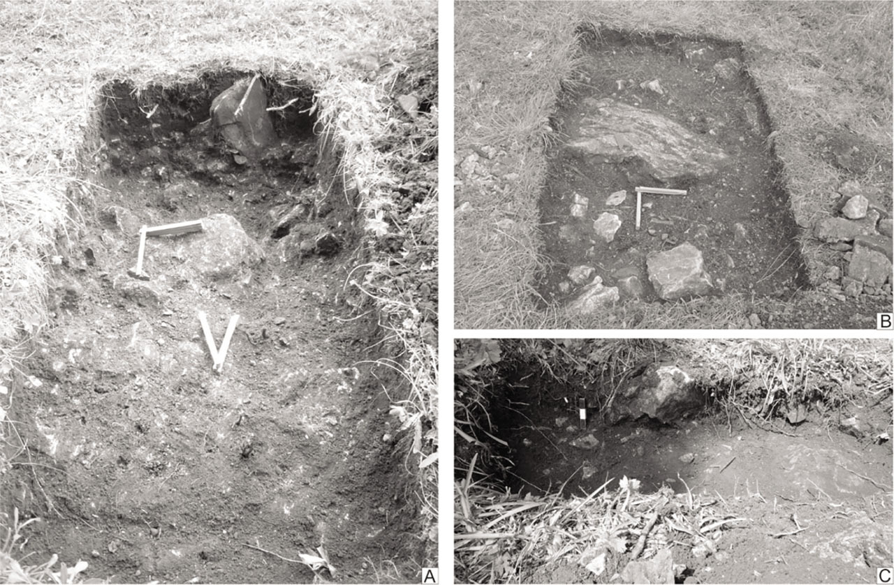
Soil samples with plant macro-remains come mainly from 2015 and 2018–2020 excavations targeted at acquisition of controlled archaeological 14C samples and new artefactual evidence (Furman et al., 2018, 2019; Benediková et al., 2020: 38, 39; Furman and Benediková, 2020; Benediková et al., in preparation). The recent fieldworks were conducted after evaluation of published archaeological data from excavations and surveys carried out through 1970s, 1990s, and in 2001 and 2004 (Pieta, 1980, 1981, 1983, 2002; Šimková, 2004; Benediková, 2006; Pieta et al., 2021). The plant macro-remains from earlier excavations investigated Eva Hajnalová (Hajnalová, 1979, 1980, 1981, 1993), whereas those from the recent fieldworks Mária Hajnalová. In 2015 at Demänovská hora and Končitý vrch, soil samples were taken from dark anthropogenic layer, a thin deposit accumulated between the grass turf and limestone bedrock with its crevices, at most 50 cm below the present surface (Figs. 5A and 5B). In the sampled spots, neither stratigraphy nor indications of spatial distribution of activities were observed. Charred seeds for 14C dating were selected from deeper soil samples. In 2020 at Iľanovská Poludnica, the soil sample was taken from the anthropogenic layer at the depth of 15–30 cm from the present surface. Its colour and texture were very similar to the two above-mentioned sites (Fig. 5C). The sampled deposit, which was collected from the layer containing pottery and iron pin from the Iron Age, was partially over and partially within the concentration of granite pebbles representing sling or throwing stones.
Fig 5.
Homogenous non-stratified cultural layer at excavated sites. A – Demänovská hora, trench III (2015); B – Končitý vrch, trench II (2015); C – Iľanovská Poludnica, trench 1 (2020). Scale in the trenches are 20 cm (1 and 2) and 5 cm (3) © Photo by Lucia Benediková.
The plant macro-remains for 14C dating were extracted from deposits using water flotation. We have also analysed the plant remains from the 1974 samples rich in charred seeds and also used one already measured 14C determination on sample from the 1974 fieldworks (Table 1). To get enough material for dating, most radiocarbon samples consist of more than one seed (Table 1). The seeds for each 14C determination were selected according to archaeobotanical expertise that they represent remains of a single archaeobotanical context (e.g. grain store; Benediková et al., in preparation).
Table 1.
Information on AMS dated plant macro-remains. Numerical codes (e.g. 19_348) represent samples pre-treated and graphitised in the radiocarbon laboratory in Prague, whereas other samples were prepared and measured in Debrecen (DeA) and Vienna (VERA) laboratories.
| Lab code | BP | Sigma | Abbrev. | Site | Year | Sample No. | Taxa | Material | No. of finds |
|---|---|---|---|---|---|---|---|---|---|
| VERA-892 | 2385 | 30 | DH74PS1 | Demänovská hora | 1974 | no data | Pisum sativum | Seed | unknown |
| 19_349 | 2397 | 21 | DH74HV | Demänovská hora | 1974 | 611 | Hordeum vulgare | Grain apex | 2 |
| 19_348 | 2520 | 20 | DH74PS2 | Demänovská hora | 1974 | 611 | Pisum sativum | Seed fragment | 2 |
| 19_356 | 2421 | 19 | DH15LC | Demänovská hora | 2015 | 1 | Lens culinaris | Seed fragment | 1 |
| 19_357 | 2445 | 18 | DH15TS | Demänovská hora | 2015 | 1 | Triticum spelta | Grain | 2 |
| 19_350 | 2236 | 20 | KV74PS | Končitý vrch | 1974 | 605 | Pisum sativum | Seed fragment | 6 |
| 19_358 | 2150 | 18 | KV15PI | Končitý vrch | 2015 | 1 | Pinus sp. | Charcoal* | 1 |
| 19_359 | 2166 | 18 | KV15PS | Končitý vrch | 2015 | 1 | Pisum sativum | Seeds | 13 |
| DeA-29815 | 849 | 21 | IP201 | Poludnica | 2020 | 1 | Pinopsida indet. | Charcoal** | 1 |
| DeA-29816 | 842 | 21 | IP202 | Poludnica | 2020 | 1 | Pinopsida indet. | Charcoal*** | 1 |
Samples for dating have not been characterised by IRMS. Graphite targets were prepared in the radiocarbon laboratories in Prague, Debrecen and Vienna (Table 1). AMS analysis was performed in Vienna (Kutschera et al., 1997; Wild et al., 1997) and in Debrecen (Molnár et al., 2013), where also targets from Prague (Kučera et al., 2022) were analysed. All chronological models and computations have been carried out in OxCal Program version 4.4.4 (Bronk Ramsey, 1995, 2009) with calibration curve IntCal20 (Reimer et al., 2020) set to a 5-year resolution. The outcomes of computations were in interpretations rounded to the nearest 10 years.
. Results
. Demänovská hora
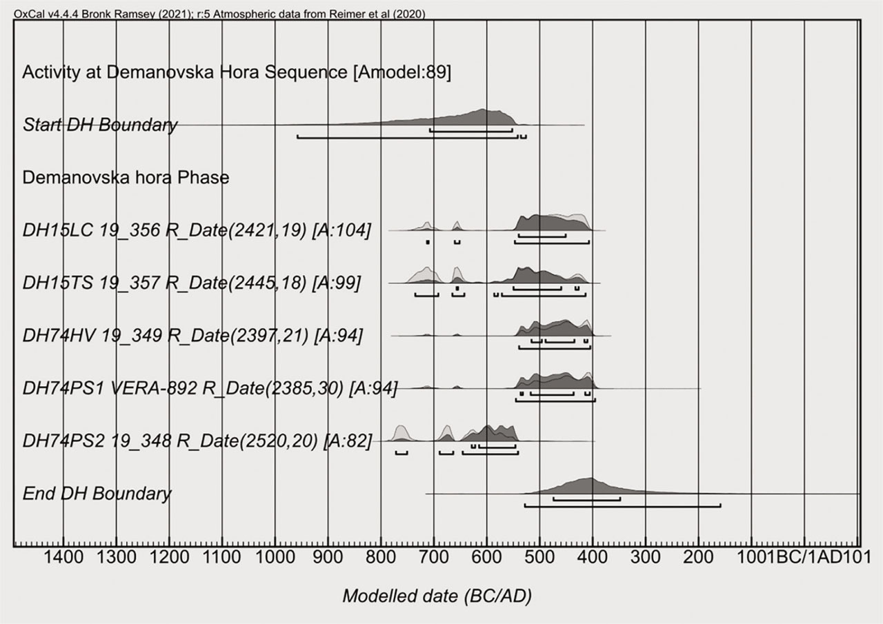
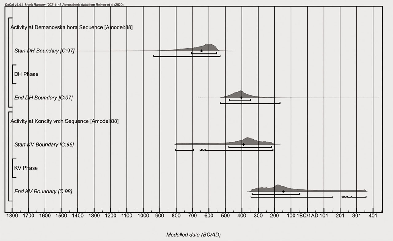
All dated charred macro-remains of peas, lentil, spelt and barley belong to the Iron Age (SOM 2). Due to the absence of informative priors and assuming uniform distribution of events (Bronk Ramsey, 1995), we have investigated the start and end of activities leading to charring of cereals and pulses at Demänovská hora by the uniform phase model (Fig. 6, SOM 3). The medians of start and end boundaries date to 647 calBC and 403 calBC.
Fig 6.
Demänovská hora. Likelihood (light grey) and posterior probability (dark grey) of 14C dates in uniform phase. All dates are included in the model. © Figure by Peter Barta.
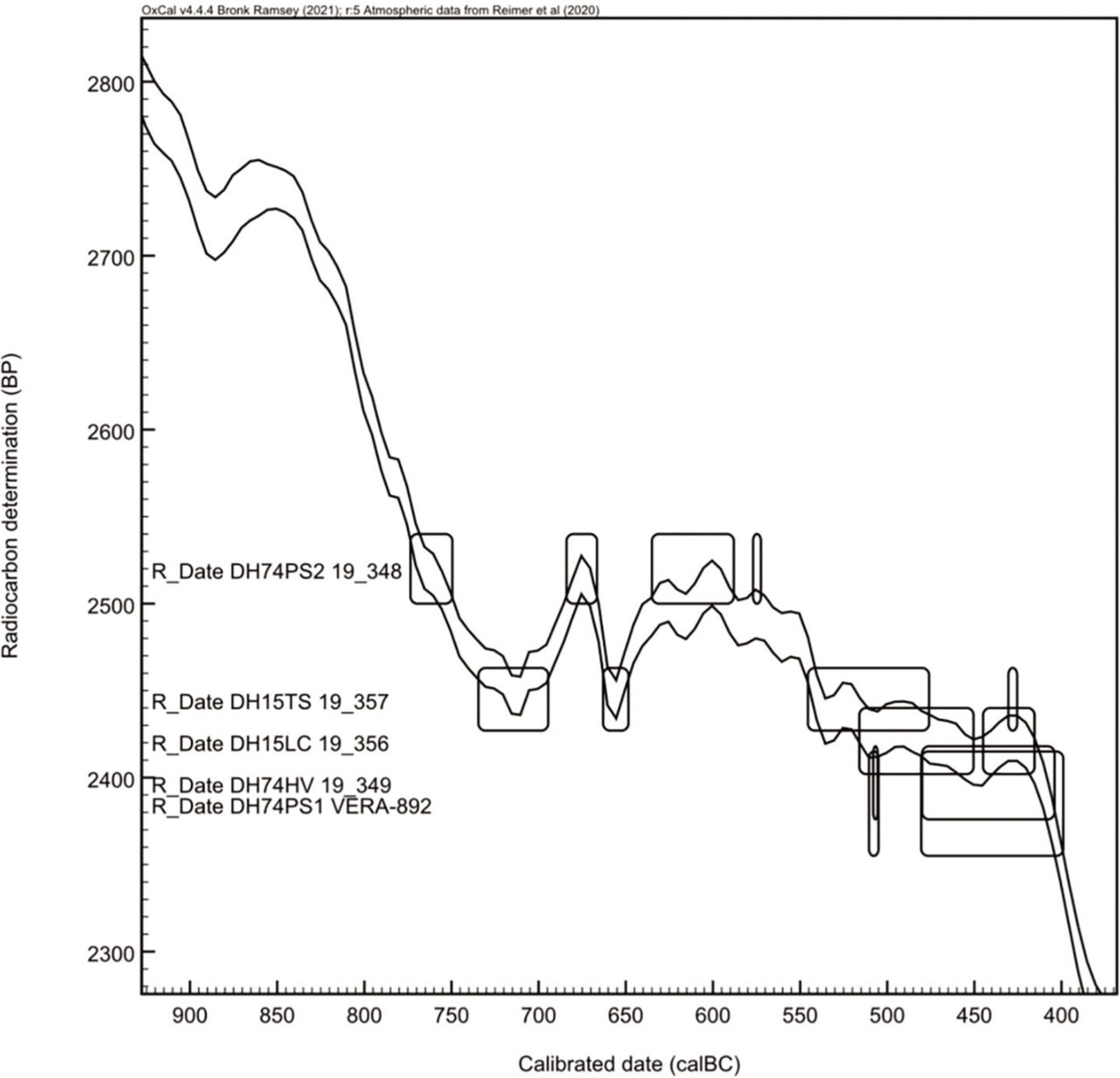
Despite the coarse chronological resolution caused by the shape of the calibration curve (Fig. 7), we tried to ascertain whether samples from the 2015 and 1974 excavations, which comprise different cereals and pulse crops, can be said to represent one or more archaeological events. For this we have employed the tool for combination before calibration (Ward and Wilson, 1978) incorporated in OxCal Program (R_Combine). As for two samples from the 2015 excavations, they could represent the same sample (grains of spelt 19_357 and seed of lentil 19_356, R_Combine (2434,14)X2-Test: df = 1 T = 0.8(5% 3.8)). As for three samples from Demänovská hora the 1974 excavations, however, seeds of peas 19_348 statistically proves not to be a part of the same sample with peas VERA-892 and barley 19_349 – the test fails at 5% (X2-Test: df = 2 T = 23.313(5% 6.0)). When 19_348 is excluded, two remaining samples are statistically coherent and could originate from the same sample (R_Combine (2393,18) X2-Test: df = 1 T = 0.1(5% 3.8)). Accordingly, when 19_348 is excluded, four samples from the Demänovská hora 1974 and 2015 fieldworks could represent a single archaeological event, for instance a single store of cereals and pulses (Test 4 R_Combine (2419,11)X2-Test: df = 3 T = 4.5(5% 7.8); details on all testing results are given in Supplementary Online Material SOM 4). However, atmospheric concentration of radiocarbon in 750–400 BC as known from IntCal20 causes that the same value of conventional radiocarbon age can be representative of different archaeological events that may be hundreds of calendar years apart (as shown by simulations for two arbitrary chosen dates 730 BC and 430 BC; SOM 5). Further, statistical scatter of observations of one event by radiocarbon method means more estimates (Buck et al., 1996), which, in the period under discussion, may look as though pertaining to non-contemporaneous archaeological events. Thus, conventional radiocarbon ages that are statistically same sensu Ward and Wilson (1978) but are physically from different samples may have been produced by archaeological events that were not contemporary. And conversely, even if the test shows that the radiocarbon ages are statistically different – which can indicate that the archaeological events reflected by the samples are different – we cannot rule out that the dated samples are of the same age. Therefore, as for the number of observable archaeological events in our 14C dated samples, we can merely speculate that charred peas 19_348 could represent an older archaeological event, while the rest of the seeds a younger one.
Fig 7.
Demänovská hora. Individually (vague-prior) calibrated 14C ages of charred seeds from excavations in 1974 and 2015. For visual clarity 68.3% probability ranges are shown. No stratigraphic relations are supposed between dated samples of crops. © Figure by Peter Barta.
As we assume no detectable time-gap between production of the crops, their transportation, storing and charring on the mountain summit, we date activity or activities leading to charring of vast amounts of pulse and cereal crops to the time window 650–400 calBC. Owing to the calibration curve shape and the lack of informative priors, the chronological resolution of radiocarbon dating remains coarse. Whether the earliest date measured on peas 19_348 is a statistical outlier or it represents a truly earlier archaeological event could be investigated if samples with strong archaeological priors would be available.
. Končitý vrch
From Končitý vrch, we have two radiocarbon dates on pea seeds and a date on a fragment of pine wood charcoal (SOM 6). Without informative priors about the samples we could here estimate the timing of charring of the crops by the uniform phase model (Bronk Ramsey, 1995) with two 14C dates on peas (SOM 7, Fig. 8). The medians of the start and end boundaries gave 391 calBC and 148 calBC (Fig. 9). As we have assumed no detectable time-gap between the production of crops in the lowland and their charring on the summit, we date the charring to 390–150 calBC.
Fig 8.
Končitý vrch. Likelihood (light grey) and posterior probability (dark grey) of 14C dates in uniform phase. Date on the charcoal fragment (19_358) is excluded from the model. © Figure by Peter Barta.
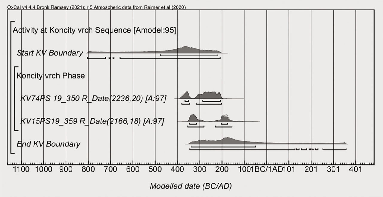
Fig 9.
Demänovská hora and Končitý vrch uniform phases. Start and end boundaries medians indicated with crosses. © Figure by Peter Barta.
The variety of crops, good preservation of seeds and their high density in the sampled matrix suggest that the context was not severely taphonomically altered. As supportive evidence on context's taphonomic integrity, we view also a 14C date on the charred pinewood 19_358, which is statistically same as that on pea 19_359 (R_Combine (2158,13)X2-Test: df = 1 T = 0.4(5% 3.8)) (SOM 8). Not to overinterpret the 14C determinations, we restrained from using the charcoal fragment in the model as terminus post quem, even if archaeological context did not rule out an interpretation of a wooden receptacle for the crops.
. Time Difference between Charring of the Crops at Demänovská hora and Končitý vrch
The above-given results indicate a time-gap between charring of the crops at Demänovská hora and Končitý vrch. According to multiple runs of the models, the median of Demänovská hora phase end boundary and the median of Končitý vrch phase start boundary are separated by around 10 years.
To estimate the minimal time-gap between activities at both sites, we have investigated the difference between closest directly and indirectly dated events, respectively.
If we viewed the charring of samples at each site as individual unrelated events, then potentially closest archaeological events took place in the latest year of the latest vague-prior calibrated date from Demänovská hora (DH74PS1 VERA-892:2385 ± 30 BP, SOM 2) and the earliest year of the earliest vague-prior calibrated date from Končitý vrch (KV74PS 19_350: 2236 ± 20 BP, SOM 6). Then, the latest alternative for charring events at Demänovská hora is 393 calBC and the earliest alternative for charring events at Končitý vrch is 382 calBC (95.4% probability). Both charring events are thus separated by around 10 years.
We also have investigated the difference between these latest and earliest directly dated events (Difference command of OxCal). The estimated difference between the two events is from 22 years to 456 years (95.4% probability; SOM 9).
As there are neither stratigraphic nor artefactual records usable as prior information about the samples, we could have not modelled time-relation (Fig. 9) between the sites. Accordingly, we have investigated the difference between the end boundary of the Demänovská hora uniform phase, i.e. the last indirectly dated event at this site, and the start boundary of the Končitý vrch uniform phase, i.e. the first indirectly dated event here. The analysis gave under 68.3% probability values from −156 years to 180 years and under 95.4% probability from −432 years to 240 years. The highest probability density was for the interval from 25 years to 80 years (SOM 10 and raw output of analysis, code in SOM 10). The results with negative values are of notice, as they also imply contemporaneity and reversal of the investigated events. However, the negative values here are the consequence of the shape of probability density functions, especially the long-tailed distribution of the start boundary of Končitý vrch (Boundary Start KV) covering the whole of the Hallstatt plateau (Fig. 9). Considering, first, the time-relation between directly (14C determinations) and indirectly (boundaries) dated events, and second, the shape of probability density functions of the boundaries, we do not see the proof of synchronicity in our 14C dates.
To sum up, our analyses indicate that activities leading to charring of crops at both sites were not contemporary. According to the analysis of difference between potentially closest directly dated archaeological events (i.e. charring activities), there is at least 20 years between them. As for the difference between the potentially closest indirectly dated events, the most probable result is from 25 to 80 years, according to the raw output from difference analysis (code in SOM 10).
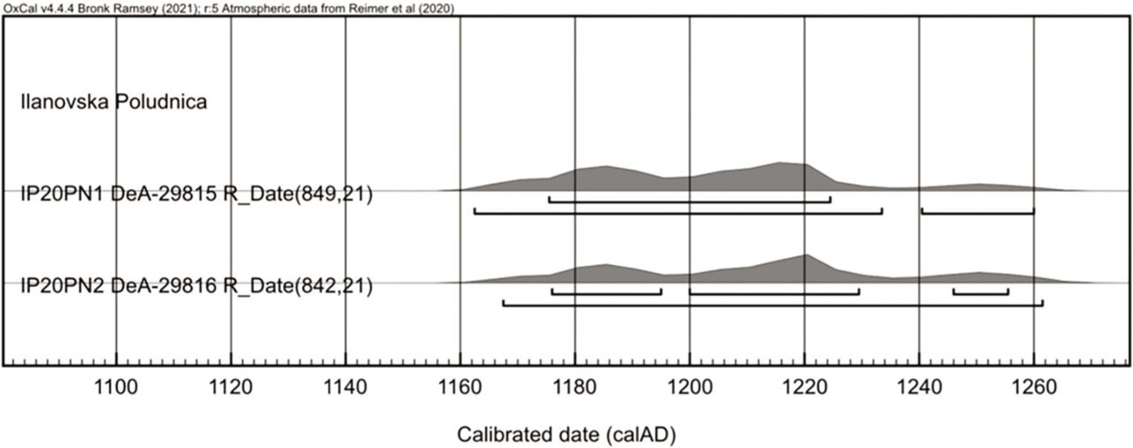
. Iľanovská Poludnica
A small twig and a fragment of wood, both of coniferous taxa, are thought to represent locally grown trees. Even if the soil sample originates from layer bearing prehistoric artefacts, both charcoals are medieval and document anthropogenic or natural events leading to charring of the wood between the mid-12th to mid-13th century calAD (Fig. 10, SOM 11). Contrary to the artefactually dated archaeological evidence from the studied context of the Late Bronze Age to the Hallstatt Period, the charcoals are of mediaeval origin.
. Discussion and Conclusion
Our new 14C dates represent the first systematically collected chronometric evidence on human activities (cf. Barta and Pieta, 2004; Barta et al., 2013) at hard-to-reach upland localities in the North of Slovakia. At three studied sites with artefacts from the Early and Late Iron Age (Demänovská hora, Končitý vrch, Iľanovská Poludnica) as well as from the Late/Final Bronze Age (Iľanovská Poludnica) we focused on 14C dating of the crops. The cereals and pulses from Demänovská hora and Končitý vrch were dated to the Iron Age. At Iľanovská Poludnica we found only charcoal fragments, which turned out to be of mediaeval date.
In our 14C dates we see no indication that the activities leading to charring of the crops at Demänovská hora and Končitý vrch were contemporary. According to a simple comparison of closest vague-prior calibrated date ranges, they are separated by 10 years (SOM 2, SOM 6). According to the analysis of difference between the closest directly dated events from both sites, the time-lapse between closest charring events is 20–330 years (SOM 9). The difference analysis of the closest indirectly dated events confirmed this result with highest probability density for the interval of 25–80 years (raw output from analysis, code in SOM 10).
Taking the medians of boundaries in uniform phases as representative for reporting the results for estimating the activity producing the large amount of charred pulse and cereal crops, we can conclude the following. At Demänovská hora, the charring is dated to 650–400 calBC (Fig. 9) and could have occurred as a single (all excluding sample 19_348) or repeated activity (sample 19_348 included) (Fig. 6). At Končitý vrch, charring occurred in 390–150 calBC (Fig. 9). Whether it was a single or repeated activity (Fig. 8) cannot be decided due to the absence of arguments for identification of artefacts of the calibration curve.
Presently, the characteristics of samples and absence of strong archaeological priors prevent us from dating the charred crops with fine chronological resolution. If the charring activities occurred repeatedly, they may have been of diverse nature. The violent destruction at Demänovská hora is strongly supported by the artefactual evidence (weaponry and fire destruction). At Končitý vrch the evidence for violent destruction is weaker and the finds of weaponry are less frequent (Pieta, 1981: 55, 1983: 40; Furman, 2020). Apart from their role as refugia, the hypothesis that the sites were used also as burnt offering places seems possible as well (more in: Benediková et al., in preparation).
Ultimately, the activities leading to large amounts of charred crops at the mountain summit sites of Demänovská hora (1304 m a. s. l.) and Končitý vrch (1310 m a. s. l.) were not contemporary and were not a consequence of a single short-time event. Even if the details remain elusive, the non-contemporaneity may well point to diverse reasons tied with local or regional cultural–historical circumstances during or at the end of the Early and during the Late Iron Age (e. g. Bujna, 1994: 9; Chochorowski, 2014; Kozubová, 2019; Teržan, 1998: 518, 519).